A load more links
I did a post a while back which was just a lot of links to things I found interesting, mostly in the geospatial/data/programming sphere. Since then I’ve collected a lot more links – so here are some of them. The theme, such as there is, seems to be ‘this would have really helped me about X contracts ago, if it had existed then/I had known about it then’. Make of that what you will…
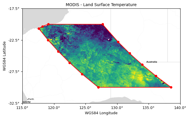
- The stac-tools raster footprint utility – a useful new-ish tool that generates nice, accurate but simple outlines (‘footprints’) for the area covered by a raster file (as shown above) all ready to put into a STAC catalog
- Is Antarctica Greening? – a brief article looking at some of the technicalities of using NDVI time series to monitor greening in Antarctica (reminds me of some of the issues I had using time series in my PhD)
- VTracer – an interactive web interface to an open-source tool to convert raster images to vector SVGs (not geospatial images, just images in general). Gives great immediate feedback on parameter changes
- tilegroxy – a proxy that can sit between end users of web map raster/vector tiles and the sources, managing things like caching, authentication etc. Seriously considering using this with my current client.
- grid-banger – a Python package for converting between Ordnance Survey grid co-ordinates and latitude/longitude. Unlike many converters, it works with both fully numerical grid references, and those that start with letters (like
TQ213455) - GeoDeep – a new and simple (but seemingly quite powerful) tool for doing basic deep learning on geospatial rasters. Can do things like extract cars, trees, buildings – and even extract road polygons (something which would have been useful a couple of clients ago…)
- LosslessCut – not geospatial or data related, but very useful: I’ve recently been digitising some old VHS tapes, and this makes it very easy to mark chunks of video files and then export each chunk to a separate file – all while keeping the quality high
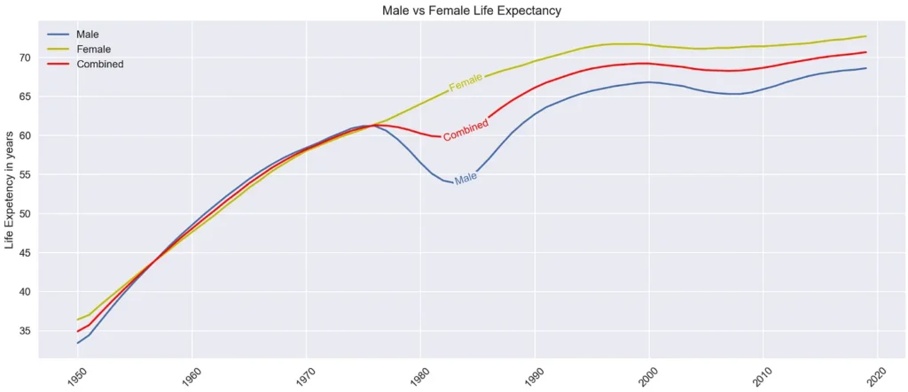
- labellines – a neat little Python package for labelling lines on a graph by putting the label inside the line, rather than relying on a separate legend (see image below)
- act – lets you run Github Actions locally, to save doing a million commits to see how your CI/deployment/etc runs. This would have saved me a lot of time about four contracts ago.
- cuttle – this one isn’t even tech related, it’s the rules for a fairly fun card game that I’ve been playing with my wife recently. Sometime I’ll do a blog post containing my player cheatsheet that I put together.
- It’s cool to care – a blog post from Alex Chan where they explain something that is very important to me: that it is cool to be enthusiastic/interested/excited by something, even if other people aren’t.
- FILTER in Postgres – simple explanation of a nice bit of SQL syntax in Postgres that allows you to write things like
SELECT COUNT(*) FILTER (WHERE b > 11) - QMapCompare plugin for QGIS – a useful plugin that lets you compare two views of a map, either side-by-side, with a swipe or with a focus area following the map
- BGNix – a 100% free way to remove backgrounds from images (again, not geospatial in this case – just things like photos or clipart). It uses an AI model that runs entirely on your local device, and so doesn’t send your images anywhere making it high-privacy too!
- Spy for changes with sys.monitoring – nice example of how to use the new
sys.monitoringfunctionality (a newer, better version ofsys.settrace) in Python to help with debugging - QGIS Deepness – a plugin for easily running deep learning models in QGIS, including a ‘model zoo’ of models that can be set up very quickly
- lonboard – I mentioned lonboard in my last list of links – it’s a Python library for creating interactive maps – but hugely faster than most alternatives. Here’s a new version with animation added, allowing some pretty cool animated maps to be made.
- geopandas – another new release, this time for geopandas with some nice new functionality
- maplibre-cog-protocol – a plugin for maplibre that lets you load COGs directly (like georaster-layer-for-leaflet does for Leaflet)

If you found this post useful, please consider buying me a coffee.
This post originally appeared on Robin's Blog.
Categorised as: Academic, GIS, Programming, Python, Remote Sensing
Leave a Reply