Beware: Latitude/Longitude co-ordinates in ENVI may not be in WGS-84
Summary: When you use the Pixel Locator or Cursor Location/Value tool in ENVI, the latitude and longitude co-ordinates given are based on the datum that the image is in, not necessarily WGS-84.
This may be obvious to some people, but it wasn’t to me – and I thought that if I got confused then some other people probably would too – hence this article. I often use the Pixel Locator dialog box in ENVI to find a specific location in the image by entering the X and Y pixel location (referred to in ENVI as Samples and Lines) or the map co-ordinates of whatever co-ordinate system the image is projected into (for example, the Ordnance Survey National Grid):
![]()
Alternatively, you can click the button with the arrows on it, and enter a location in latitude and longitude:
![]()
Very handily, all of these values are updated as you move around the image manually – so this dialog can also be used as an equivalent of the Pixel Location/Value window – as shown below.
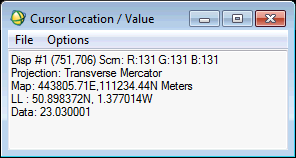
This all sounds fine – but the problem is that the latitude/longitude values that are shown are calculated using the datum that is defined for the image. You can see this in the image below, where the latitude and longitude value is displayed, and the datum is listed above it:
![]()
This seems like a sensible thing to do, but it makes comparison with latitude and longitude co-ordinates from other sources very difficult – as nearly all other latitude and longitude co-ordinates are provided in the WGS-84 datum. Locations from GPS systems are always in WGS-84, and locations on web maps, in GIS systems and most other sources of latitude and longitude co-ordinate systems are very frequently in WGS-84.
So, this raises two questions:
What effect does this have?
Well, I haven’t yet done a full investigation of this (sometime I will sit down and write some code to do some proper testing), but when I found the problem it was causing offsets of around 100-200m – which can be quite significant in many applications.
What can we do about this?
There is a way to tell ENVI to use WGS-84 as the datum for calculating its latitude and longitude values, but it is a bit fiddly. Basically, when you’re in the Pixel Locator dialog before you switch to the latitude/longitude display, click the Change Proj… button and then select click the Datum button to select a new datum. Then switch to the latitude/longitude display, and you’ll find that the datum is listed as WGS-84, and the values will be correct in the WGS-84 datum:
![]()
Unfortunately, this means that the map co-ordinate values (for example, the Ordnance Survey Grid References) will now be wrong, and you’ll need to switch back to the original datum to get those to be correct. Also, I can’t find a way to get the Cursor Location/Value dialog to display WGS-84 latitudes and longitudes.
I actually found this while designing a lecture and practical session for MSc students at the University of Southampton on using the ENVI API in IDL. While writing a code example for the students on finding the pixel value at a specific lat/lon co-ordinate, I found that my results came up between ten and twenty pixels away from the place I thought they would (I was using 10m SPOT imagery), and I got different results from my IDL code and ENVI – even though my IDL code was using the ENVI API! Luckily I managed to find out what the problem was – and could therefore explain it to my students, and hopefully stop them running in to the same problem as me. It may be that I’m being silly here, and everyone naturally realises what ENVI does, and thinks it is the right thing to do – but it definitely confused me, so maybe it will helped you.
If you found this post useful, please consider buying me a coffee.
This post originally appeared on Robin's Blog.
Categorised as: Academic, GIS, IDL, Remote Sensing
Leave a Reply