British Placename Mapper – follow-up and links to cool maps
A couple of weeks ago, I released the British Placename Mapper, which is a website that allows you to search place names in Great Britain and show them on a map. You can do searches like finding all the places starting with ‘great’, or ending with ‘burgh’ or containing ‘sea’. I tweeted and tooted about it, and it went a bit viral. Overall, since I launched it on 30th March, it has had over 17,500 visitors who have performed 110,000 searches using it. The average user spent over two minutes on the site, which is quite high for a webpage these days (obviously this is an average, and some people spent ages and others left almost immediately). This post is to share some of the cool things that people have come up with, and the cool places that it has been mentioned online. I’ll do another follow-up sometime in the future to talk about the technical aspects behind the app.
Cool maps
So, first let’s have a look at the cool maps that people created with it. I was very pleased that I managed to make a ‘copy link to these settings’ button on the app, which allowed users to share direct URLs to the specific settings they had configured – this allowed people on social media to share their favourite maps. When listing maps below I’ve tried to include screenshots of the most popular maps (click on them to view them full size), plus direct app links too. These maps aren’t in any particular order, and don’t cover all maps that were made using it – these are just my favourites.
Danelaw area
Various people commented that by searching for certain name endings you could pretty accurately show the Danelaw area, defined by Wikipedia as "the part of England in which the laws of the Danes held sway and dominated those of the Anglo-Saxons". This map shows names ending in "thwaite" in red and "by" in blue:
Comparing this to a map of the Danelaw extent (in pink) from Wikipedia shows quite a good match:
Palindromes
This doesn’t tell you anything interesting about history, but it’s still one of my favourite maps here. This map shows places that have palindromic names – that is, they read the same forwards as backwards – like Eye and Notton.
London & Little London
There are a lot more places named after London than I thought there would be, including loads of places called Little London. From a bit more research, the origin of a lot of the Little London placenames are disputed, but there are suggestions they may have come from people escaping the Black Death or the Plague and moving to these villages, or from evacuee’s destinations in the Second World War. See here for the interactive map, and below for Little London in purple, and anything else containing London in red.
Ham/Ley
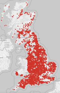
These two common endings show that they’re nearly all in England, and there are particular concentrations of one or the other – for example, "ham" in East Anglia, and "ley" in the West Midlands, Lancashire and Yorkshire.

Street
Names ending in "street" seem to be concentrated in southern East Anglia and Kent, but do exist elsewhere – see here.
Higher/Upper
This is fascinating: places containing "higher" only seem to occur in Devon/Cornwall and Lancashire, whereas "upper" is spread more evenly throughout a lot of the south and the midlands of England. See here:
Bourne
In British English, a "bourne" is an intermittent stream. I’m sure someone with more geological knowledge than me could link some of the clusters on this map to the underlying geology.
Ton
There are some fascinating patterns with the suffix "ton", in this map. The gap in a ring around London – where there are places ending in "ton" in London and away from London, but not in a ring around parts of the home counties, is interesting – someone on Twitter referred to this as the "Saxon gap", but I can’t find anything about it online. There are also some very distinctive clusters in South Wales – I wondered if these may be related to English-speaking parts of Wales, but a number of the places seem to be in quite rural areas – including relatively remote areas on the West coast. Interesting!
le
Searching for le as a separate word finds places like Thorpe le Street and Chapel-en-le-Frith, which all seem to be concentrated in northern England. It seems strange to have what sounds like a French-inspired part of a name so far away from France, but I’m sure it’s due to some sort of invasion from someone at some point.
Cornwall
Looking at places starting with tre clearly outlines Cornwall (stopping very sharply at the Tamar) and Wales, and worthy seems popular in Corwall and Devon.
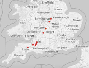
Fosse
Place names with fosse in them clearly outline the path of the Fosse Way a Roman Road:

Church/Kirk
As expected, the church/kirk split is a north/south split, but I was surprised how far south the usage of the word kirk came, with the most southerly examples well into the midlands.
Valleys
This map shows a range of words for "valley", from various languages brought by various peoples. They pretty neatly divide the country into chunks – note the very clustered group of places containing "clough".
Red/Green/Blue
When looking at a map of places including these colours I was expecting to see relatively few places with "blue" in the name (there aren’t that many things in nature that are blue), but was surprised how many places with "red" in the name there were.
Some others:
- royd: in Yorkshire, an area of cleared forest land was known as a "royd" and this appears in a tight cluster of place names
- names for streams: this shows various different names for a stream (beck, brook etc)
- less common letters: there are still quite a lot of places with "z", "q" and "j" in their names
- apostrophes : this shows apostrophes anywhere in the name, compared to apostrophes surrounded by letters (like John O’Groats). There are loads of places in southern England named after people (X’s Corner, X’s Green etc).
- prime ministers: the surnames of recent-ish British Prime Ministers gives a few potentials for map-based political jokes (if you’re into that sort of thing…)
- US placenames – who knew there were so many places in the UK called California?!
One final interesting thing is this tweet and the responses to it. Someone has compared the map of "thwaite" and "kirk" and compared it to a species abundance map for the plant Sand Leek and they match extremely closely. I’ve no idea what this means, and if it is causal – but it’s definitely interesting.
Places it was mentioned
As well as going a bit viral on social media, the placename mapper was mentioned on:
- Hacker News – some of the comments are interesting
- a Financial Times blog
- a couple of newsletters – here and here
- the WeeklyOSM newsletter – well worth a read for interesting geo things (OSM and non-OSM)
- a few family history websites (here, here and here), which actually provided quite a high number of visitors
- b3ta
- Metafilter Projects
As well as being mentioned in these places, I got a lot of nice tweets and comments saying how interesting people have found it, which was very pleasing.
I’m hoping to do some extensions to this work in future – maybe for other countries, or for other names in the UK (this only included settlements – but I could extend it to include names of rivers, lakes, forests, mountains etc). Drop me a comment, an email, a tweet or a toot to let me know what you’d like me to do next (and if you really enjoyed this app then please feel free to buy me a coffee).
If you found this post useful, please consider buying me a coffee.
This post originally appeared on Robin's Blog.


[…] British Placename Mapper – follow-up and links to cool maps […]
[…] were both for my British Placename Mapper web app, which is described in more detail in this blog post. If you haven’t seen it already, I strongly recommend you check it […]