Fun with the OS Gazetteer
As part of the OS Open Data initiative the Ordnance Survey has released a free version of their 1:50,000 scale gazetteer. This lists all of the names shown on the 1:50,000 scale OS maps, linked to information such as their location (in both Ordnance Survey grid references and WGS84 latitude/longitude pairs) and type (city, town, water feature etc). I’ve had a little play with this data to do some statistics on it and see if I can find out anything interesting. Hopefully you’ll agree that at least some of the stuff below is interesting.
My main statistical analysis was to count the frequency of each name in the gazetteer, and then extract the ten most commonly-used names for each of the feature types listed in the database.
Cities:
No cities in the UK share a name with another city.
Towns:
There are 1,245 towns in the dataset and the results here are slightly more interesting – the winner is Seaton, of which there are three (in Cornwall, Devon and Yorkshire). This isn’t particularly surprising as Seaton was probably derived from Sea Town, and given that we are an island nation, there is a lot of sea by which towns could be located! A number of names are well-known for belonging to two towns in the UK, such as Newport, St. Ives and Ashford, but there are 12 such towns, listed below:
- Armadale
- Ashford
- Gillingham
- Heathfield
- Newport
- Ramsey
- Richmond
- Rothwell
- Royston
- Slough
- St Ives
- Swinton
Other settlements:
This is where it starts to get more interesting, but also more confusing. The feature type of Other Settlements seems to include anything that’s not a town or a city and there are over 34,000 of them. Nearly 31,000 of these are unique (a fairly impressive feat), but a number of them seem to be more popular than the rest – the top ten are listed below and include three variations on calling a place a new town (New Town, Newtown and Newton) as well as a number of other names relating the settlements to their location (West End, North End, East End) or what is there (Church End).
| Newtown | 55 |
| West End | 49 |
| Newton | 48 |
| Church End | 42 |
| North End | 36 |
| New Town | 32 |
| Upton | 32 |
| Milton | 30 |
| East End | 28 |
| Mount Pleasant | 26 |
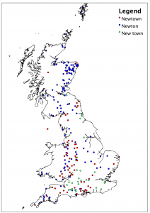
I was intrigued by the differences between the names of New Town, Newtown and Newton and wondered if there may be differences across the country in which name was used. Also, I wondered whether any areas of the country had significantly more of these new settlements than others. The map below shows the distribution of the three names across the country (click to see a larger version):
A number of patterns are noticeable:
- There seem to be a lot of these settlements around the Welsh border (the area known as the Welsh Marches). I’d suspect this is because of the frequently changing location of the border in this area, leading both sides to rename a town as ‘new’ once they’d captured (or re-captured) it.
- There is a distinct lack of these settlements in central Wales – fairly obviously, as most names there are in Welsh
- Scotland has far more Newtons than any other version of the name, and these are concentrated on the eastern side of the country.
- New town seems to be far more common in southern England, although there is a concentration of Newtons in Cornwall.
I’m not sure what exactly one can learn from the above, but it’s interesting to me at least. If anyone has any ideas which explain the distribution of these names better then leave a comment.
If you found this post useful, please consider buying me a coffee.
This post originally appeared on Robin's Blog.

Very interesting. Makes a change from work 😉
I wonder how many of these relate to people being thrown off land or towns being ‘moved’ as a result of the enclosure acts?
Great blog and interesting to see the settlement pattern around the Welsh border.