More links – June 2025
I’ve got into a bit of a habit of writing occasional posts with links to interesting things I’ve found (probably because it’s a relatively easy blog post to write). This is another of those posts – this time, written in June 2025. So, let’s get on with some links:
- Why COUNT(*) can be slow in Postgres: a good delve into how Postgres works ‘under the hood’ and why that means that counting rows can sometimes be quite time-consuming
- f2: handy command-line tool for bulk-renaming files, with the default mode being a dry-run
- Tree Species Map for England: a new open dataset from Defra which shows species of trees across the UK
- Leaflet v2.0 alpha: an alpha version of a new major version of Leaflet, the web mapping library. I actually tend to use MapLibre these days (it seems faster for MVTs, though I haven’t tested that properly), but I prefer the Leaflet API and tend to use it for simpler applications. The new version seems to tidy up a lot of stuff, which is good.
- cqlalchemy: this is a handy library (named after SQLAlchemy and almost impossible to pronounce in a way that makes clear it is different) for writing Common Query Language queries, as used with many STAC catalogs. It’s a right pain to write these queries by hand, and they often have to be structured weirdly in JSON, but this library will do it all for you.
- stac-fastapi-geoparquet: this is a backend for the stac-fastapi tool (a STAC server written in FastAPI) that lets you store the STAC catalog in GeoParquet rather than in the standard options of a Postgres database (via pgstac) or ElasticSearch. Storing STAC information in GeoParquet files is something I’ve been keeping an eye on for a while, and there are some interesting talks on it – like this one.
- stac-auth-proxy: One final STAC-related link, this time an authentication proxy to run a private, secured STAC server. This is something I implemented a proof of concept of myself with a previous client, and it’s nice to see there’s something ‘off the shelf’ for it now.
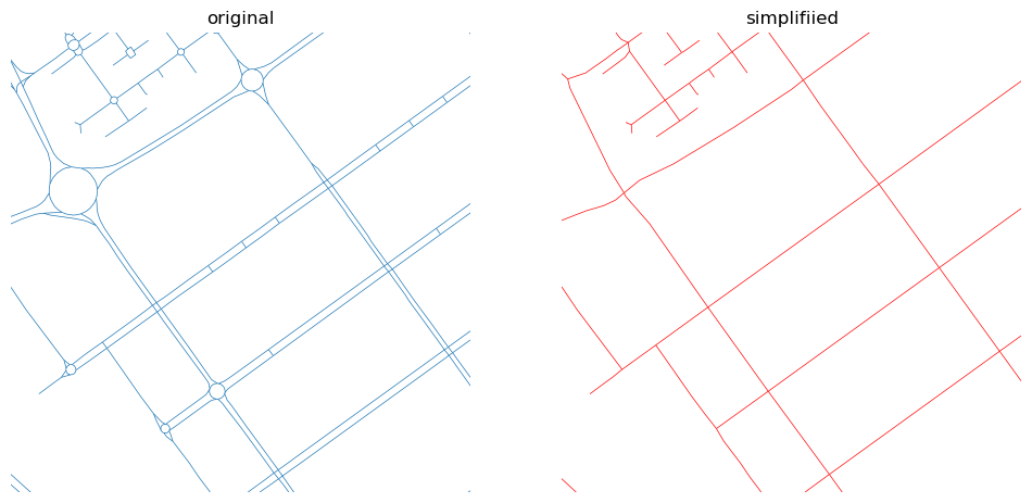
- Simplification of street networks: A nice description of a Python tool to simplify street networks, removing things like sliproads, roundabouts and so on, and just leaving the correct topology there. It’s quite a nice tool, but also a nice approach to solving the problem.
- Promptfoo: This looks like a good tool for evaluating AI model responses – easily configurable, open-source etc. There’s a good description of the tool and links to other resources on Simon’s blog. Another interesting post on evals for AI model responses is here.
- Adding notes to exceptions in Python: a brief post explaining a new feature in Python 3.11 which allows you to add handy notes to exceptions – I could see this being useful for some more complex errors in some of my libraries
- How to get auto-complete to automatically appear in pgAdmin: I’m not a massive fan of pgAdmin, but I’ve tried a range of Postgres GUIs and haven’t really found one I like more (yet…). This little change to the settings in pgAdmin will make it pop up the autocomplete dropdown when writing SQL queries just while you’re typing, rather than waiting for you to press a key combination – making everything a little bit smoother.
- Design for 3D printing: I’ve been getting quite into 3D printing recently (I’m hoping to write a post on it soon), and this is a great, very detailed, article on how to design items ready for 3D printing. I learnt a lot!
- llm can run tools now: Simon’s llm command-line tool and Python library can now use the ‘tool usage’ pattern with local tools defined very easily as Python functions. Seems very powerful, and a lot simpler than some other approaches.
If you found this post useful, please consider buying me a coffee.
This post originally appeared on Robin's Blog.
Categorised as: Academic, Computing, GIS, Programming, Python, Remote Sensing
Leave a Reply